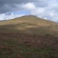
Sugar Loaf photos
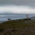
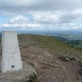
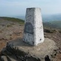
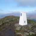
Triangulation Station on top of Sugar Loaf

and licensed for reuse under this Creative Commons Licence


Hover over the map markers to see associated photo. Note, some markers show photographer's position whilst others show photo subject location.
['Triangulation Station on top of Sugar Loaf',51.8627,-3.05787,'/public/geophotos/406113.jpg'],['Walkers on the Sugar Loaf / Mynydd Pen y Fal',51.8626,-3.05787,'/public/geophotos/2954702.jpg'],['Summit of Sugar Loaf',51.8627,-3.05802,'/public/geophotos/655678.jpg'],['Sugarloaf, Abergavenny',51.8627,-3.05802,'/public/geophotos/1239791.jpg'],['Sugar Loaf summit in August',51.8627,-3.05802,'/public/geophotos/2548560.jpg'],['On the Sugar Loaf summit cone',51.8627,-3.05802,'/public/geophotos/2954617.jpg'],['The summit trig point on the Sugar Loaf',51.8627,-3.05802,'/public/geophotos/2954670.jpg'],['Sugarloaf top rocks',51.8629,-3.05788,'/public/geophotos/1300368.jpg'],['The Sugar Loaf summit trig point',51.8628,-3.05773,'/public/geophotos/2149990.jpg'],['Sugar Loaf from the Kymin',51.8628,-3.05773,'/public/geophotos/2163387.jpg']