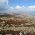
Round Knott photos
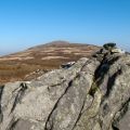
Summit vegetation and rock tor of Round Knott

and licensed for reuse under this Creative Commons Licence


Hover over the map markers to see associated photo. Note, some markers show photographer's position whilst others show photo subject location.
['Summit vegetation and rock tor of Round Knott',54.6942,-3.03433,'/public/geophotos/2626545.jpg'],['Round Knott',54.6944,-3.03434,'/public/geophotos/2595335.jpg'],['Round Knott',54.6943,-3.03449,'/public/geophotos/652949.jpg'],['Round Knott',54.6943,-3.03449,'/public/geophotos/2331879.jpg'],['Round Knott',54.6944,-3.03449,'/public/geophotos/1046711.jpg'],['Round Knott.',54.6939,-3.03479,'/public/geophotos/89690.jpg'],['Round Knott',54.6939,-3.03479,'/public/geophotos/196222.jpg'],['Round Knott',54.6956,-3.03453,'/public/geophotos/1506534.jpg'],['Rock outcrop, Round Knott',54.6953,-3.03514,'/public/geophotos/604878.jpg'],['On Carrock Fell',54.6955,-3.03608,'/public/geophotos/2331887.jpg']